
GPS system
In this activity you'll find an animation depicting how the GPS system works.
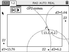
Being a 2D construction only 3 satellites, S1, S2 and S3, are needed to determine the coordinates of any point.
Throughout the animation you'll see:
- The distances to the three satellites, d1, d2 and d3;
- The circle centered in S1 with radius d1;
- The circle centered in S2 with radius d2;
- The circle centered in S3 with radius d3;
- Point P, in the intersection of the three circles and its coordinates.
Then the animation restarts, with P in a new position. Everytime the animation is ran the coordinates of P are determined randomly.
Download the GPS animation in: